- A5 booklet type
- Matte/glossy thick paper
- Title: State of the Map Asia Conference x Asia Resilience Forum
- Some full page graphic + Logo
- Sponsors platinum (small)
- Mapbox, Visions
| #!/usr/bin/env python3 | |
| ''' | |
| pip install tqdm numpy pillow mercantile 'rasterio==1.0b1' 'rio-tiler==1.0a7' | |
| ''' | |
| import os | |
| import argparse |
| #!/bin/bash | |
| # | |
| # ogrcat | |
| # produces line-delimited geojson features | |
| # Like `fio cat` but uses ogr2ogr under the hood | |
| ECHO_FEATURES="" | |
| ogr2ogr -f GeoJSON /vsistdout/ "$@" | while read line |
| #! /bin/bash -ex | |
| # Convert Landsat 8 GeoTIFF images into RGB pan-sharpened JPEGs. | |
| # | |
| # Requirements: | |
| # * gdal http://www.mapbox.com/tilemill/docs/guides/gdal/ | |
| # * Dan Stahlke's https://github.com/gina-alaska/dans-gdal-scripts | |
| # * convert (image-magick) | |
| # | |
| # Reference info: |
| <!DOCTYPE html> | |
| <html> | |
| <head> | |
| <meta charset='utf-8' /> | |
| <title></title> | |
| <meta name='viewport' content='initial-scale=1,maximum-scale=1,user-scalable=no' /> | |
| <script src='https://api.tiles.mapbox.com/mapbox-gl-js/v0.26.0/mapbox-gl.js'></script> | |
| <link href='https://api.tiles.mapbox.com/mapbox-gl-js/v0.26.0/mapbox-gl.css' rel='stylesheet' /> | |
| <style> | |
| body { margin:0; padding:0; } |
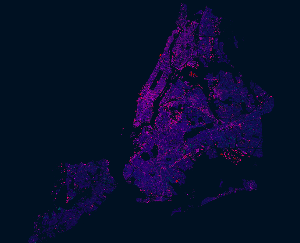
NYC had an import of over 1 million building footprints and 900,000 addresses in 2014 from the New York City Department of Information Technology and Telecommunications (DoITT). The DoITT GIS releases an updated shapefile of the footprints every quarter, and the latest version can be accessed here: Building footprints | Address points
Open datasets like these are a great opportunity to explore how OSM can be used as a bridge between authoritative information and that crowdsourced by citizens. Two years after the import, it is interesting to see how the OSM data compares with the latest official footprints. The interesting questions to ask is:
The OSM-PH community have been monitoring this user for years. Since his previous edits were mostly in the Philippines, we are trying to resolve this within the local community. But lately, we noticed he has started editing in other parts of the world and on "highly valuable" OSM features. We feel we should escalate monitoring by sharing this to the larger OSM community.
OSM userid: 688302, 698612, 2041564, 3179745, 3318041, 3431335, 3611662
We think these are vandalism/harmful edit accounts of the same person (identfying as he based on username) for the following reasons:
http://geohub.lacity.org/datasets/813fcefde1f64b209103107b26a8909f_0
cat Building_Footprints.prj
PROJCS["NAD83_California_zone_5_ftUS",GEOGCS["GCS_North_American_1983",DATUM["D_North_American_1983",SPHEROID["GRS_1980",6378137,298.257222101]],PRIMEM["Greenwich",0],UNIT["Degree",0.017453292519943295]],PROJECTION["Lambert_Conformal_Conic"],PARAMETER["standard_parallel_1",35.46666666666667],PARAMETER["standard_parallel_2",34.03333333333333],PARAMETER["latitude_of_origin",33.5],PARAMETER["central_meridian",-118],PARAMETER["false_easting",6561666.667],PARAMETER["false_northing",1640416.667],UNIT["Foot_US",0.30480060960121924]]