Skip to content

Instantly share code, notes, and snippets.

@lxbarth
lxbarth / PiuraWorkshopHeyPost.md
Last active February 22, 2016 17:34 — forked from mikelmaron/PiuraWorkshopHeyPost.md
Mapbox in Mapgive's Workshop in Piura-Peru

Mapbox in Mapgive's Workshop in Piura, Peru

image Before - After Map of Piura

Last week, Ruben and I helped lead an OpenStreetMap workshop in Piura - Perú, set up by Tom Gertin from MapGive/US State departament. This event was promoted by Embassy Lima, MapGive, Piura University and Regional Goverment of Piura.

As the local Spanish speaking OpenStreetMap experts we walked attendees through mapping techniques and got them excited about the project. The workshop helps to grow the OpenStreetMap community in Peru, introduces attendees to Mapbox and helps build our relationship with the US Department of State and the Lima Embassy around OpenStreetMap and MapGive.

Bui

Mapbox in Mapgive's Workshop in Cusco-Peru

Last week Ruben and I took part in a workshop in Cuzco with Mikel and Erika from MapGive / US State Department. This Workshop was part of the Cusco Secondary Cities Project. Mikel led the workshop with a translator and Erika, Ruben and I jumped in with helping people hands on through the exercises.

There were four learning processes involved in the workshop;

  • Data collection using OpenMapkit, Fieldpaper and Mapillary
  • Adding collected data to OpenStreetMap
  • Extracting data from OpenstreetMap
  • Using extracted data in Cuscogeonode and Mapbox.com

Por fin en Ayacucho!

Al fin en Ayacucho!

Acabo de mudarme desde Lima a Ayacucho. A partir de Lunes esta semana estaré trabjando tiempo completo junto el equipo aquí en la oficina en Ayacucho.

Me gusta estar aqui en la Pueblo Natal, me gusta mucho trabajar en Ayacucho por su hermoso clima y sus paisajes.

Estoy muy entusiasmado de incorporarme al equipo de Ayacucho, vengo para Aprender y Trabajar con todos mis compañeros.

Reviewer notes of edition file 968 (2015-05-08)

user:ramyaragupathy

Incorrect identification of unclassified road

user:Rub21

Tagging of service roads

A quarter million US roads added and aligned

Since September 2012 our team has aligned 260,309 roads in the United States. For this process we use fresh US government TIGER data to show where OpenStreetMap data is out of date, then we trace from imagery as needed and use road names from TIGER. (For a background on TIGER data in OpenStreetMap read Eric Fischer's blog post).

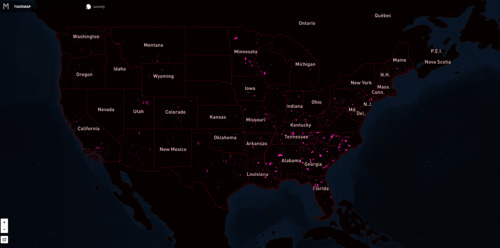
Here's the map showing the extent of the issue. Pink lines are the progress over US. Full interactive map.

We continue our work on TIGER with @MateoV's recent analysis that further focuses our TIGER work. This analysis looks only at areas with high Twitter

A quarter million US roads added and aligned

Since September 2012 our team has aligned 260,309 roads in the United States. For this process we use fresh US government TIGER data (for a background read Eric Fischer's blog post) to show where OpenStreetMap data is out of date, then we trace from imagery as needed and use road names from TIGER.

Here's the map showing the extent of the issue. Pink lines are the progress over US. Full interactive map.

We continue our work on TIGER with @MateoV's recent analysis that focuses on TIGER issues in areas with high Twitter traffic, missing roads, naming issues and road lengths ov

260 309 US roads added and aligned

Since SEPTEMBER 2012 our team has aligned 260 309 roads in the United States. For this process we use fresh US government TIGER data (for a background read Eric Fischer's blog post) to show where OpenStreetMap data is out of date, then we trace from imagery as needed and use road names from TIGER.

Here's the map showing the extent of the issue. Pink lines are the progress over US. Full interactive map.

XX,000 US roads added and aligned

Since MONTH YEAR our team has aligned XX,000 roads in the United States. For this process we use fresh US government TIGER data (for a background read Eric Fischer's blog post) to show where OpenStreetMap data is out of date, then we trace from imagery as needed and use road names from TIGER.

Here's the map showing the extent of the issue. Pink lines are the progress over US. Full interactive map.

![]()
@lxbarth
lxbarth / 0_reuse_code.js
Last active August 29, 2015 14:17
Here are some things you can do with Gists in GistBox.
// Use Gists to store code you would like to remember later on
console.log(window); // log the "window" object to the console

Mapeando mi vecindad

Luis, Edith haremos una pausa en trazado de los Edificios en San Francisco. Esta pausa es para que ustedes puedan hacer algo diferente, pueden trabajar en sus vecindades o los lugares donde viven, será divertido para ustedes trabajar en los lugares donde más conocen, y que disfruten mapeando.

Ejemplo: